Abstract
In early 2004, I was contacted by the Lincoln City Visitor and Convention Bureau to explore the feasibility of locating the shipwreck burried in the sands of Siletz Bay by geophysical methods. In July of 2004, the team assembled at the bay to assess possible geophysical techniques, take photgraphs, and make a GPS-based map of the site. Armed with historic photos, our photos, and the GPS map, we were able to narrow the search range. After some consideration, the team agreed on a technique. In 2005, a magnetometer survey was done aided by GPS positioning data. Near the end of 2007, the data processing was complete and interpretation of the data was possible.
History
The Siletz Indian Reservation Agent, Ben Simpson, recorded in 1864 [1] that a large ship purported to be the Blanco was "wrecked a few days since at the mouth of the Siletz River. I have just returned from an examination of the vessel. She is a total wreck; her masts are gone, her deck broken in, her hull is split from deck to keel, and I fear her crew are all lost."
There is some uncertainty that the ship was indeed the brig, the Blanco. According to the Lincoln City Visitor and Convention Bureau the wreck may have been the Phoebe Fay, the Uncle Sam, or the Sunbeam all of which were schooners. Irregardless, eye witness accounts have seen the wreckage in the 1960's and one photograph taken in the 1950s. Moreover, two samples of timbers purported to have been taken from the wreckage exist; one is in the possession of the North Lincoln County Historical Museum.
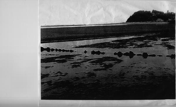
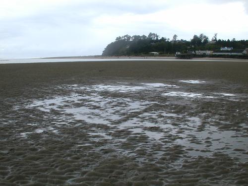
An historic photograph (left) showing the ribs of the ship protruding from the sand (Courtesy of LCVCB). The picture on the right shows a modern view of the same site (Photo by the author).
[1] - "The Pioneer History of North Lincoln County, Oregon, Vol. 1," North Lincoln Pioneer and Historical Association, November 1951.
Approach
The first task was to narrow the search area to a managable size. However, local eyewitnesses have placed the wreck in greatly different locations according to interviews conduced in 2004. Instead, the search area was narrowed using several historic photographs. Landmarks in the backgrounds of the photographs including the wreckage were used to triangulate its approximate position. Once the search area was narrowed to a square less than 50 meters on a side, a GPS survey was done in 2004 to record the search site along with landmarks.
Since the survey site is underwater except during extreem minus tides, we had to wait until June of 2005. It was felt that with the presence of iron-based minerals in the sands of Siletz bay, that magnetometry w ould be the best tool to find the wreck. Grains comprised of iron-based minerals are rather much heavier than the other, mostly quartz, particles, hence these magnetic grains tend to collect around obstructions in the sand bar. An illustration of this may be seen by examining a fist-sized rock half-burried in the sand - you observe black, iron-based, grains collect on the leeward side of the rock.
A cart was fitted with 3 fluxgate magnetometers and one Cesium magnetometer, a differential GPS system, a laptop running linux as a data acquition system, and appropriate battery power to aid the magnetic survey. The magnetometer cart was dubbed Beachcomber I.
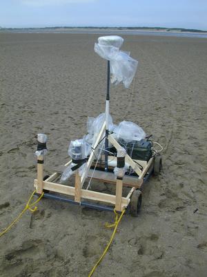
Beachcomber I
Surveys & Summary of Results
Pictures of fragments perported to be from the wreck.
2004 Survey - Background & Narrowing the Survey Site
2005 Survey - Background & Assement
The results are not conclusive, but are compelling. We detected a clear region in the survey region that stands out (seen as red and blue in the figure, below) above the background (green). Please see the above links for details about the survey.
It is compelling that the orientation of the wreck seen in the historic photograph and the orientation and size of the red and blue region in our survey agree. It is hardly conclusive, but is suggestive that we have detected and pinpointed the resting place of the fated ship.
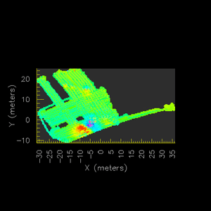
A colour rendition of a Cesium magnetometer survey